In this info-packed article, Qii.AI’s VP of Innovations, expert drone pilot and technologist, Ian Hannah recounts our company’s early lessons learned in drone inspections and how they shaped the development of Qii.AI and goes on to explain in detail how to ensure success with Qii.AI through best data-capture practices.
Qii.AI software was born out of the real-world experience, acquired starting from the earliest days of the drone revolution. Operating in that environment gave us some advantages, but it also meant we had to learn by doing; there were no textbooks or online forums discussing how to gather data using drone technologies. We found out early on, that drones can collect massive amounts of images and data. Our software, Qii.AI came from the need to find a way to effectively manage this data, make it meaningful, and allow users to really harness their powerful new remotely piloted systems.
We learned about photogrammetry and its ability to create digital twins. We learned about digital twins and why they were important, but we also figured out that a digital twin is not always required or possible to acquire.
We made sure that our software could handle not just visual imagery, but thermal as well because the inspection markets we were working in used thermal extensively, and we understood the importance of accommodating both.
We have tried to make Qii.AI fit with our real-world experience, which meant it needed to be flexible to accommodate the many ways of gathering data, using many different cameras from many different positions. Our goal was to make all this data easy to use, easy to generate reports out of, and securely sharable with team members and clients. We also knew that our software needed the security and speed of a desktop and the convenience of a web app.
From our real-world experience, we knew it isn’t always possible or required to make a digital twin model, so we had to ensure Qii.AI could accommodate simple visual or thermal inspection where often the speed with which information is turned around, is the most critical factor.
Your inspection may not require a 3D model, or you may not have time or the access required. The first thing to do is understand the scope of work - what is being looked for. Be sure your preparation and method of capture satisfies that scope. Qii.AI can manage and handle geo-tagged data that is done without the need for building any digital twin. It is fast and intuitive, working within a 2D map view.
Let’s look at what Qii.AI needs from its users. As mentioned, Qii.AI can use photogrammetry to create 3D models of objects. Photogrammetry is a fascinating subject. In short, it uses the ability of different viewpoints with known positions to create depth, in the same way, your two eyes create depth perception by your brain knowing how far apart they are. There are many web resources you can search on the subject if you wish to learn more in-depth about science.
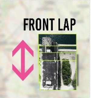
Overlap 75% or higher this is for both front lap and side lap (don’t forget that overlap has front and side options). Use the best camera and lens you have - the quality of the image makes a difference - the higher the megapixels the better the quality. In thermal you need a higher, 85-90% Overlap.
Single fixed focal length. Any variable zooming causes problems for processing. If you need close-ups, get as physically close to the object as you safely can. If you cannot get close enough and must change focal lengths to zoom in, then we recommend you consider using Qii.AI in its 2D mode, which uses GPS positioning for location.
GPS: Images should be geo-located, if possible. In indoor environments or under bridges, this may not be possible, but 3D models can still be created using visual references with high overlaps. As well as consistent close-ups, be sure you get wider sequences that allow the software to stitch images together. We know GCPs (Ground Control Points) can help in building a 3D model and improve accuracy. We also learned they are not often necessary when building models for visual inspections.
Consistency. Pictures should be taken from the same distance in an orderly, organized way. (Flight planning software is good for making sure this happens, although we know it’s not always possible to use software to fly structures).
No Blur. This means sharp in focus imagery. (Use auto or preset focus before take-off). It also means no motion blur, so high shutter speeds (and/or slowing the flight down).
Environmental conditions
Shadows and the position of the sun can cause stitching issues. The ideal is a bright, overcast day, but when that isn’t possible, try and get the imagery in the same environmental conditions. The more organized you are, the quicker the data can be captured, so make sure everything is as pre-planned as possible.
We suggest avoiding sky and open water as much as possible in your imagery. These are often homogeneous and can include moving objects such as clouds and waves, which can cause “noise” in the imagery and result in stitching failures. Tilt your camera down slightly to avoid the sky when you get high enough to it in the frame.
Challenges:
If you are creating a 3D model for Qii.AI, you may face challenges whenever parts of the structure are homogeneous, looking the same all over. Often, shots of concrete buildings can appear almost identical from one image to another. Sky or open water in the background can also cause problems or “noise” around the point cloud.
For homogeneous structures you can move further away or use a wider fixed focal length lens. This will allow more of the object to be seen with a greater chance of capturing objects in the image that the software can recognize for stitching purposes.
We also suggest tilting the camera towards the ground a little (10-25 degrees) which will reveal more of the object in the frame and it can help avoid sky.
Structures
There are many types of structure you will face and each one will require a different approach.
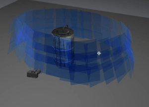 Towers can be done two different ways: in circular flight paths around the object or if that isn’t possible, by flying overlapping vertical paths around the object. Conducting circular paths is relatively easy to program with flight planning software, assuming there is room enough around the structure and it isn’t blocked by other structures.
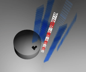
If you have a problem with the location of objects in the way, you can fly in vertical paths surrounding the object, ensuring you have enough overlap for a complete 360 model.
If you are flying a flare stack you have the additional issue of heat, if it is operational. (first, see if it is). You may wish to consider using zoom and using the geotagged 2D map view in this case. Be aware heat from the flare extends far past the visible flame. You can get a better view of the flare by looking down on it or ideally, use a thermal camera.
Lattice towers can cause challenges because of the fine beams or wires. To fly this kind of object, the best approach is always the usual of keeping the sky from the picture and using a very dense overlap with the highest quality camera you have.
Bridges
Bridges present unique issues, as at some point you may not be able to fly using GPS. This will require good piloting skills and will mean you will not be able to fly using pre-programmed flight paths.
On the underside of the bridge, follow the advice of slow consistent flights, taking photos with a high degree of overlap.
Be aware of the exposure, looking up into the bridge can cause issues if you fly on auto-exposure. Any extra light entering the lens by looking upwards can cause the image to be too dark. Manual adjustment may be required.
Without GPS signals, the 2D map option cannot be used, so it is best to assume that a 3D model approach will be most successful. Often GPS can be there, but is marginal and unreliable, in which case it is better to switch it off and fly without it.
Buildings
Buildings are often made up of flat planes with four or more sides and a roof. Capturing images is dependent on the type of exterior the building has. Those with highly reflective glass will be a problem, as it can be very hard for the software to stitch. You may be forced to fly quite far back, defeating the reason for the inspection. Other buildings may be similar and homogeneous, calling for wider shots to make work. The same rules about a slight tilt down and avoiding sky applies to buildings as to other structures.
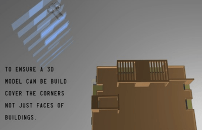
One thing to ensure is that you get the corners of the buildings so you can see both walls in the shot. You will need this sequence to tie the whole structure together, otherwise, you may just have flat planes rather than a 3d model.
Flying the roof will be the easiest and can be pre-programmed. If possible, ensure you fly past the roof line so you can see down the walls, which will help tie the whole model together.
Buildings can be tricky because of their location, next to busy streets or pushed up against other buildings.
If 3D capture is too challenging, remember Qii.AI can also work using just the geo-positioning of the system.
Ground-Based
Note: Qii.AI is agnostic when it comes to aerial versus ground-based data capture. If using a ground-based camera, ensure that GPS is enabled, which will help build the digital twin, as it would with aerial capture. You can use geo-tagged, ground-based photos in Qii.AI 2D map view, as there is no requirement to build a 3D model. The principles are the same as aerial - be sure to avoid a lot of sky and keep a consistent distance from the target object
Thermal
One area we have spent a lot of time doing data capture is in the thermal spectrum. The key points we have learned include having as high-resolution a camera as you can, at least 640x 480. The lower the resolution, the higher will be the required overlap, which is greater than with visual data, closer to 90% front and side. You should also have the highest Hz camera you can, to reduce motion blur. This, combined with a reasonably slow flight, will help keep the images sharp.
We have found greyscale has proved easier to stitch than coloured palettes, so where possible we advise working in greyscale when dealing with thermal data.
Finally, remember to be careful with auto settings; wild changes in images can occur when the camera automatically adjusts to what it sees in the frame. If possible, use manual settings and adjust gently during the flight.
Applying our years of in-field experience conducting drone-based inspections of buildings, bridges, power stations, towers, and tanks, of all sizes and materials, we developed Qii.AI for the remote visual inspection market to make your work easier when it comes to managing, sharing, and analyzing your visual and thermal inspection imagery. Easy to use and intuitive, Qii.AI, with artificial intelligence tools, will rapidly improve the efficiency and effectiveness of your drone inspection program workflow, all the more so, now that you know how to fly so that Qii.AI works at its best for you!